
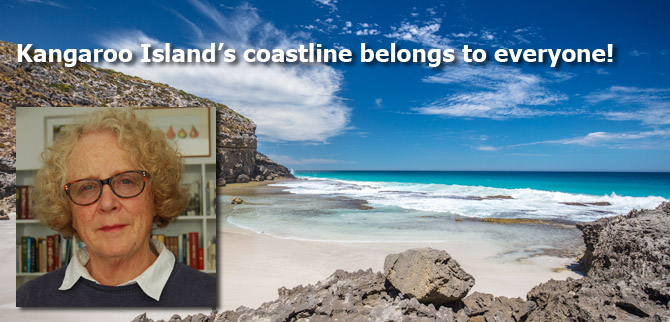
Have we won yet? How our community waged a successful campaign against a golf course development on Kangaroo island by Kathie Stove.
Kathie Stove is a freelance writer and editor who lives on Kangaroo Island, South Australia. For more than 20 years, Kathie has written on topics such as ecology and biodiversity, arts, cycling, social services and education, for newspapers, magazines, websites and newsletters. She thought she would be a botanist when she completed her BSc at the University of Adelaide while a technician at the State Herbarium of South Australia; but life took her to editing, especially in environment and other science fields. She is a certified editor of the Board of Editors in the Life Sciences, and is a Distinguished Editor, awarded by IPEd, the peak body for Australian editors. Kathie’s writing has become an equal interest and she blogs on the nature and art of Kangaroo Island and tweets randomly @kathiestove
She is a keen promoter of, and volunteer for, the natural Kangaroo Island environment and for island’s visual arts. Kathie is a member of the Kangaroo Island Natural Resources Management Board and leads an association formed to build an Art Museum of Kangaroo Island.
“In accordance with section 4(c) of the Crown Land Management Act, the Minister has considered the social, economic and environmental aspects of the proposal and has declined to sell the waterfront land for this development.”
This announcement on 14 February 2018 from the South Australia Minister for Sustainability, Environment and Conservation concluded a short, intense community-based campaign against a change to a development that was pretending not to be a change.
It all began with a proposal from a developer to build a golf course on “cleared degraded” farmland on the isthmus that joins the eastern Dudley Peninsula with the main body of Kangaroo Island. Bear with me while I run through the timeline. In February 2014 the proposal was given Major Development Status by the South Australian Government. The Minister for Planning can declare a proposed development or land use a major development if it is of state economic, social or environmental significance, and if a declaration is required for appropriate assessment. Declaration starts a “rigorous, whole of government assessment process”. A state assessment panel considers the application and identifies the key social, environmental and economic issues relevant to the assessment of the proposal, and consults state agencies to ensure all aspects of the proposal are considered. It then sets the level of assessment required and issues formal guidelines.
The Development Assessment Commission released guidelines in July 2014 for assessing a proposal by the developers, Programmed Turnpoint Pty Ltd, who had to prepare a Public Environmental Report (PER) which requires an in-depth investigation of the issues surrounding the proposal. A PER is not as rigorous as an environmental impact statement.
The PER was to contain the need for, and a description of, the proposal. It had to assess expected environmental, social and economic effects; and ensure consistency with government policy, the relevant development plan and regional planning strategy. The PER should also demonstrate that the proposed action is consistent with relevant guidelines or plans under the federal Environment Protection and Biodiversity Conservation Act (EPBC Act which lists species that have conservation protection under it).
The PER was released for public comment on 14 May 2015. Public comments closed on 30 June 2015, allowing a period for comment five days longer than the mandatory minimum six weeks. During that period, several public meetings were held, and displays shown, in local halls in Penneshaw and Kingscote.
The response document to public and agency comments was released on 17 September 2015. Of the 30 publicly released responses received, more than half were not in favour of the development. Many in favour of it were completed on the comment forms available at displays and public meetings. One favourable submission, from Business Kangaroo Island, stated that it represented 97 members.
It would be fair to say that a large majority of Kangaroo Islanders approved of the development. Jobs for locals, especially young people, are scarce on the island and the promise of them is almost always greeted with hope. Parents want their children to stay on the island and find work.
Those who stated concerns spoke of species protected under the EPBC Act; over abundance of native animals; runoff from the development finding its way into Pelican Lagoon Marine Park Sanctuary zone; intrusion of the course onto the Coastal Conservation Zone with intact dune vegetation in the eastern section; the siting of accommodation next to native vegetation of very good condition and diversity; Aboriginal heritage concerns for archaeological sites in the area; traffic and bushfire management; the clearly under-priced estimated cost of $14 million for the development overall; the lack of sufficient detail and analysis to reach a strong conclusion on this specific site; and, the incongruity of an upmarket golf course on an island trying to brand itself as natural.
The main concern expressed was that sufficient water for a golf course was not available on the site. In fact the area is in a bit of a rain shadow and the rainfall trend indicates that improvement is most unlikely.
The developer’s solution had been to propose they construct a water supply pipeline branching off from the main line running from Middle River reservoir to the main KI town of Kingscote. The branch pipeline would be 35 km in length.
The developers requested up to 150 ML a year for irrigation. SA Water, which manages water delivery in South Australia, stipulated that water from Middle River reservoir would be available only in winter-period months from mid-May to mid-October, and when water is spilling from the reservoir; and no increase to the storage capacity of the reservoir would be required. Farmers in the Middle River catchment have to comply with strict water resource limitations.
The water would be held over from October to May in a 100 ML dam constructed on the golf course site from which water would be taken as needed for irrigation of the course. The branch pipeline would pass within 10 km of the town of American River, population 238 people (2016 Australian Census data), which has been asking for a piped water supply for at least 60 years and still does not have one.
The South Australian Government released its assessment report, which instructs the proponent on the conditions of the development, and the Governor of South Australia granted development approval to the project on 18 February 2017. Substantial work had to begin within two years, and the development had to be completed within five years. The approval also delegated to the Minister for Planning the power to vary the development authorisation granted for the Kangaroo Island Golf Course Resort, under the Development Act 1993.
Those who had opposed the development were obviously disappointed but acknowledged that in the scheme of things it was not the worst development given approval. And as time went on no progress had be made on turning the first sod and the two year limit was approaching fast. Perhaps the development wouldn’t happen.
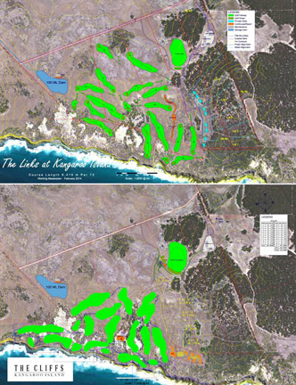
The Government Gazette 30 May 2017, 15 months after the original approval, published an approval by the planning minister under delegation from the governor. The golf course layout had been revised.
A mere one month earlier, on 26 April 2017, Kangaroo Island Links Pty Ltd, now being the beneficiary of the development authorisation, sought a variation to it to modify the layout of the development. The owners were different, though some of the people involved were the same; the golf course, clubhouse/lodge and tourist accommodation (including a hotel) had been repositioned towards the southern boundary of the site to be closer to the coastline; and the golf course was now substantially on the Coastal Conservation Zone, where the vegetation was largely intact.
A new coastal native vegetation assessment supported the high ecological value of the coastal vegetation. Several local scientists said that it omitted noting that several mammal (for example the nationally endangered Southern Brown Bandicoot) and bird species listed as threatened in state and federal legislation were likely to be in the area, and that the assessment did not use the latest accepted methods.
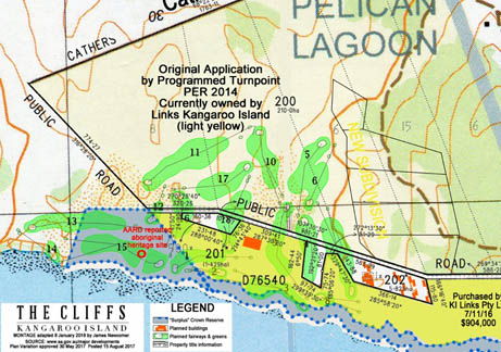
Image: Adapted by James Newcomer from www.sa.gov.au, Major Developments

However, the Planning Minister was ‘satisfied that the Public Environmental Report and Assessment Report prepared in relation to the proposed Major Development are appropriate and have had regard, when considering the proposed Major Development, to all relevant matters under Section 48 [of the Development Act]’. That is, the development was not substantially different from the original proposal.
There are no appeal rights against the decision of the Governor, or his delegate.
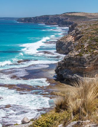
Fortunately, there was another avenue to fight this decision. The Crown Land Management Act 2009 committed ownership of Crown land to the Minister for Sustainability, Environment and Conservation in October 2011. The developer needed to gain control though lease or ownership of the waterfront (Crown) land to realise the new layout. That land ran along the coast for a distance of 2.4 kilometres, mostly at a width of about 50 metres but opening out to a trapezoid 250 metres at its widest. For the disposal to proceed the state environment department had to consider the land surplus to its requirements, meaning there were no significant conservation or heritage values that warranted retention of the land in Crown ownership.
Once Crown land is considered surplus, one means of disposal is the lessee or owner of adjoining land applying to purchase it. This was the case here.
But if someone wants to purchase waterfront land, the public also gets a say.
The YourSay website initiated by the SA Government of the time, could be said to be democracy in action. Of course, only the knowledgeable, the engaged and the web-savvy will take this option to have their say.
Of the 54 projects for which comments were sought between 1 July 2017 and 28 February 2018 on the YourSay site, only seven received comments from more than 10 contributors. Half the projects (27) received no or one comment.
Consideration of waterfront Crown land at Pelican Lagoon, Kangaroo Island received 340 comments from 274 contributors between 12 December 2017 and 15 January 2018 – the Australian summer holiday period.
Local people, many originally in favour of the plan, now wrote against it. They wrote to their friends and colleagues, had a car sticker printed and got their local federal member of parliament on the case. Submissions came in from South Australians who view the island as a natural treasure, from conservation and environment organisations, the Kangaroo Island Natural Resources Management Board, the National Trust of South Australia, a Ramindjeri spokesperson, state and local walking clubs, scientists and science organisations, archaeologists, a tourism academic, tour guides and more.
There were other ways to comment – directly to the minister or to the environment department’s Kangaroo Island regional director. Overall “780 submissions about the proposed sale of the land were received from members of the public on Kangaroo Island, the broader community and interested stakeholders. All but five of the submissions received in the public consultation period raised significant concerns about ongoing public access to the land and the protection of native flora and fauna, including a white-bellied sea eagle and the southern brown bandicoot.” (Minister’s decision by email)
The community’s stance had changed; no, it had just about reversed. Why?
Those who want the environment of Kangaroo Island and its priceless biodiversity protected hadn’t changed their minds, though more of them spoke up.
It’s possible that the effrontery of taking away the right of any person to access the coastal strip that girts the island was the main reason. Many submissions against the sale of the Crown land made that point.
But it was the mood of the community, and the talk around the traps, that the government underhandedly sanctioned the change to the golf course layout and pretended that it was scarcely different from the original proposal. That was the step too far.
In a world where money holds more sway than the future of nature, we might consider where is the line for standing up and fighting for decency and fairness. The golf course development has given us a picture of whereabouts the line is for Kangaroo Islanders
And what can happen now?
The South Australian Crown Land Development Act is a form of a sieve. Even a non-legal reader can see a myriad ways of acquiring land. An owner of land has preferred status for acquiring adjacent land; waterfront land can be subdivided so that only a minimal strip is classed as waterfront; once land is leased under the strictest of conditions, those conditions can be changed, and have been in the past.
This story is not over. On Kangaroo Island, we wait for the next move.
© Kathie Stove